Release 3.10
Deployed on November 5, 2026
This release brings GTS to the phones of supervisors. The dashboard has a new layout for phones and tablets, and from their phone supervisors can now be guided to any place shown on the map — a targeted area not yet visited, the last track point of a team, a data collection point — to check the work on the ground or join a team, without leaving GTS. It also adds a direct OData endpoint for exporting raw tracks from large Tracking Rounds.
Improvements & New Features
GTS on phones and tablets The dashboard has a new layout for screens narrower than 1024 pixels. On the map: a blue app header with the menu (public link, export, administration), a compact round header that expands to show all the indicators, round buttons for search, layers, base map and zoom, and a Table | Map bar with the period selector; search, layers and base map open in panels made for touch. The Tracking Round selection shows one view at a time (List or Timeline) with a filter panel, and the administration pages get a list of tabs, a button to open the map of a round, and tables and windows that fit the screen. The details window of an object of the map also fits the screen. Computers keep their layout; the Tracking Round page of the administration only gets a Map button (#6428, #6514). See Mobile phones and small screens, On a phone and the Administrator guide.
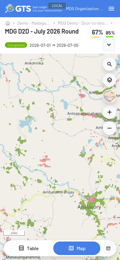
Map of a round on a phone
Guide me to this location A new Guide me to this location button in the details of targeted areas, track points, data collection points and stationary activity sites — or a long press anywhere on the map (right-click on a computer) — turns the map into a guidance screen. It shows your position, the target, an arrow that turns with the compass of the phone, the direction to follow (for example Head northwest) and the distance in a straight line, and tells you when you have arrived or are inside the targeted area. Your position stays on your phone, the screen stays on, and the guidance keeps working without internet once started. Open in Google Maps remains available for directions by road (#6509). See Guide Me to a Location.
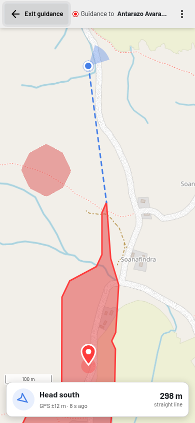
Guidance to a targeted area on a phone
Tracking Round selection timeline Hold Ctrl and turn the mouse wheel over the timeline (or pinch on a trackpad) to zoom the timeline around the pointed date, instead of zooming the whole page. The timeline keeps the same height when you move or zoom it, so the table below no longer jumps, and the number of Tracking Rounds in the dates range is shown in its bottom left corner (#6536). See Tracking Round Selection (Map Wizard).
Additional base maps for a Field Activity Focal Points can add their own base maps to a Field Activity, for example recent satellite images of the campaign area. Maxar imagery can also be added when the required token is configured. These base maps appear in the selector of the map of all its Tracking Rounds, after Satellite; the thumbnail shows the current map name (#6461, #6540). See Map Overview and Additional base maps in the Administrator guide.
Details of stationary activity sites on the map Click a stationary activity site on the map to see its ID, visit days, duration, activity type and teams; Show area indicators opens the Activity tab of the area of the site (the same button in the details of a targeted area opens the Areas view). Each site keeps the same ID from one night to the next, shown in the Activity tab and in the ID column of the stationary activity sheets of the Geocoverage Indicators export (#6475). See Stationary campaigns and fixed posts.
Same team option for stationary activity rules Each activity type of the stationary activity configuration has a new option, Require visits from the same team. When it is ticked, a site gets this type only if one team visited it on enough days (Min. number of days with visit); visits of different teams no longer add up. It is off by default, so existing rules work as before (#6473). See Stationary campaigns and fixed posts.
Stationary activity updates during indicator calculations Tracking Rounds using the newer stationary-activity algorithm (V2) process new tracks as part of the normal indicator update, rather than waiting for the separate nightly clustering. The legacy clustering algorithm (V1) continues to run nightly (#6474).
Message when the clock of the device is wrong When the date, time or time zone of a computer or phone was wrong, GTS kept returning to the sign-in page without explanation. It now shows a Clock synchronization error message, in English and French, that asks to set the date and time of the device to automatic and to reload the page (#6441). See GTS Overview.
No hidden default round for new Field Activities New Field Activities no longer get the hidden “All tracking data” Tracking Round. Create a Tracking Round to see their data on the map. Existing Field Activities keep their default round (#6427).
Stationary activity counts by team In team mode, the side panel now shows how many stationary activity sites relate to each team (#6480).
Export unvisited Targeted Areas The global export dialog can include unvisited Targeted Areas in a shapefile. The export follows the selected calendar period, either cumulative or for one day (#6543).
End-of-round report in microplan moderation The microplan moderation page now provides a download link for the health facility end-of-round report (#6559).
Feature counts for Targeted Area stack levels Targeted Area configuration now labels each stack entry as a Base Layer or Targeted Area and shows the source and included feature counts for each stack level. This helps focal points identify layers and find levels with missing or excluded features (#6554, #6643).
Clickable map search locations Click a location in the map search breadcrumbs to open that location in the indicator panel (#6495).
Names on locked localities Microplan moderation now shows the name of the CSB that locked a locality, so teams can see who planned its visit (#6487).
Direct OData export of raw tracks The
raw_trackendpoint reads live and archived GPS tracks without area intersections or materialized views. Requests must filter to a time window of at most 24 hours and can follow continuation links, so large rounds can be exported in batches without the standard whole-round 20 GB estimate. Reading archived tracks can take longer (#6508). See Export raw tracks with OData.
Bug Fixes & Corrections
Tracking Round selection filters Reset of the organization and activity filters raised an error and did not always refresh the timeline. It now clears the filters and refreshes the timeline (#6429).
Tracking Round bars in the timeline When a Field Activity had several overlapping rounds, their bars were drawn on the border of its line and could run into the next organization. Each bar is now on the line of its activity, overlapping rounds are shown one below the other, and the line of today no longer crosses the dates (#6536).
Navigation to a track point The navigation icon in the details of a track point opened the place tapped on the map rather than the track point itself, up to about 100 m away when the map was zoomed out, and did not work on iPhones. It is replaced by Guide me to this location, which uses the exact position of the point (#6509).
Map refresh after new indicators After the first computation, the map stopped checking for new indicators: the New indicators computed window did not open and old values stayed on screen until the page was reloaded. GTS now checks every 20 seconds and proposes to reload after each computation; hovering the spinning icon shows what is running (#6470). See Map Overview.
Data panel columns When scrolling or sorting the list of areas or teams in the data panel, some values were shifted and no longer lined up with their column titles. The columns now stay aligned (#6468). See Map Indicators and Panels.
Long area names in the data panel Long area names overlapped in the Areas list of the data panel. Names now stay on one line; hover a name to read it in full, or click the icon next to the column title (Show full labels) to show all names in full (#6383). See Geo-Coverage Investigation.
Attributes of an existing base layer When editing a base layer, the Data view only showed the Unique ID and Label columns. It now also shows all the other attributes of the features (#6447).
Deleted base layers removed from maps An additional base layer could remain in the map selector and administration after it was deleted. Deleted base layers are now removed from both places (#5906).
Page of expired download links The page shown when a download link has expired did not display the GTS logo, and its support link opened the wrong e-mail address. The logo is fixed and the link now opens an e-mail to the GTS support (#6446). See Downloads and GPS tracks.
Teams deployment kept for old tracks and restored rounds The numbers of teams entered in Teams Deployment could be lost when old tracks were loaded back from the archive storage, or when an archived Tracking Round was restored. The Teams report. indicator then had no plan to compare with. These numbers are now kept (#6476).
Microplans and archived tracks Use visit history filter now also uses old tracks moved to the archive storage, so localities already visited are no longer proposed again. Health facility validations are kept when an archived round is restored, and microplan download links are no longer shown once archiving has deleted the files (#6476). See Auto Microplanning (Administrators).
Team activity status for stationary-only rounds When a Tracking Round used stationary activity detection without door-to-door tracking, teams could appear inactive even after a recent detected visit. The team status now reflects stationary activity (#6479).
Microplan exports kept during Tracking Round cleanup Cleanup no longer permanently removes generated microplan exports without a recoverable copy. Restoring a round keeps its export files available (#6546).
Faster microplan moderation page The moderation page no longer rescans all moderation rows for every health facility. Its settings and summary load sooner on rounds with many moderation records (#6557).