Door-to-door campaigns
In a door-to-door (house-to-house) campaign, such as a polio vaccination round, a bed-net distribution or a household enumeration, teams walk through every settlement of their area. The main risk is that some settlements are missed: they are small, remote, or between the areas of two teams, and nobody notices until the post-campaign survey.
GTS reduces this risk by showing, every day of the campaign, which settlements have been reached by a team and which have not, based on the GPS tracks recorded by the phones of the teams. Supervisors can then redirect teams while the campaign is still running and plan the mop-up day on facts rather than on tally sheets only.
This page describes the end-to-end workflow, using the MDG Demo - Door-to-door Campaign Field Activity and its MDG D2D - July 2026 Round (1 to 5 July 2026) of the MDG demo. Checklists for each phase are given in Door-to-door campaign checklists.
The campaign cycle
Phase |
What you do in GTS |
Why it matters |
|---|---|---|
Prepare |
Create the Tracking Round, upload the Targeted Areas, set the visit rule, the team codes and the expected teams. |
The quality of the monitoring depends on the quality of the target list and on realistic expectations per area. |
Track |
Teams carry a phone with GTS Tracker running during working hours and upload their data. |
No upload, no visibility: data completeness must be checked every day. |
Monitor |
Review geographic coverage and team reporting on the map, every day, by area and by day. |
Gaps found on day 2 can still be closed on day 3. |
Mop-up |
Export the list of settlements not visited and assign them to mop-up teams. |
Mop-up resources go where they are needed. |
Report and learn |
Download tracks and indicators, feed reports, and reuse the missed settlements for the next microplan. |
Each round improves the next one. |
1. Prepare the campaign
Most of the preparation is done by the Organization or Field Activity Focal Point in the administration. The detailed screens are described in the Administrator guide.
Define what must be visited
GTS measures coverage against a list of Targeted Areas: usually settlements, grid cells of populated areas, or any polygon that a team is expected to visit. In the MDG D2D demo round, the Targeted Areas are the 1,988 settlement polygons of the communes Analavory and Anosibe Ifanja (Miarinarivo district), grouped by District, Commune, Fokontany and Locality (the base layers).
Prepare the Targeted Areas layer as described in Create a Targeted Areas layer, with a population estimate if available. See Campaign input files for the files a round needs and who prepares them.
In the Tracking Round, open the Targeted Areas tab, upload the layer and choose the base layers used to aggregate the results (from the largest to the smallest area). These levels are the levels you will drill through on the map and in the exports.
Add the indicators you want to follow, such as the population of the visited settlements, in the Geocoverage Indicators tab.

Targeted Areas tab of the MDG D2D demo round: the uploaded file, the door-to-door strategy (no minimum duration), stationary activity detection not configured, and the base layers used to aggregate the results, from Admin 2 - Districts to Admin 5 - Localities
Define when a settlement counts as visited
In step 2. Strategy & Configuration of the Targeted Areas wizard, select Door to door (Tracks intersecting with TA will trigger visitations based on configuration) and set its Minimum duration in minutes.
A Targeted Area is counted as visited on a day when one team has spent at least this minimum duration inside it, adding up all its valid GPS points of the day in that area. The MDG D2D - July 2026 Round keeps 0 minutes, so any valid GPS point recorded inside a settlement counts; the MDG RI round uses 15 minutes.
A minimum duration avoids counting a team that only drove through a settlement. Choose a value that matches the time really needed to cover a small settlement; a value too high hides real visits.
If the Targeted Areas layer has a
duration_mattribute (for example a longer time for large settlements), it is used instead of the general value for those areas. Its value is currently read in seconds (1800 for 30 minutes, see Create a Targeted Areas layer).Only valid GPS points are used: points recorded at a speed outside the limits set for the Field Activity (for example in a vehicle) are ignored.
Stationary activity detection can be enabled in addition, when some teams also run fixed posts (see Stationary campaigns and fixed posts).
Plan the teams
In Team Codes, enter the list of team codes, so that team members select their code in GTS Tracker instead of typing it. Free text leads to spelling variations that split one team into several.
In Teams Deployment, enter how many teams are expected per area, Day by day or for the whole period. GTS compares this plan with the teams actually reporting (Teams report. indicator on the map). See the screenshot in Routine Immunization monitoring.
Prepare the devices
Install GTS Store, GTS Tracker and GTS Collect on the phones (Mobile Apps Overview), pass the 1. Open GTS Tracker: Requirements Screen screen and charge the devices before the first day. See also the pre-campaign checklist in Door-to-door campaign checklists.
2. Track in the field
During working hours, GTS Tracker records the position of the phone at regular intervals, without action from the team. Team members only need to:
log in and select their team code at the start of the day;
keep the phone charged and the application running;
upload the data, ideally every evening when a network is available.
Optional ODK forms in GTS Collect can record additional information (for example a household or a refusal), geolocated and linked to the team. See 4. Fill in an ODK Form.
Tip
Coverage on the map can only be as complete as the uploads. Each evening, check in the map or in Teams report. that every expected team has sent data, and follow up with the teams that did not.
3. Monitor coverage every day
Open the map of the Tracking Round from the Tracking Round Selection page (see Tracking Round Selection (Map Wizard) and Map Overview).
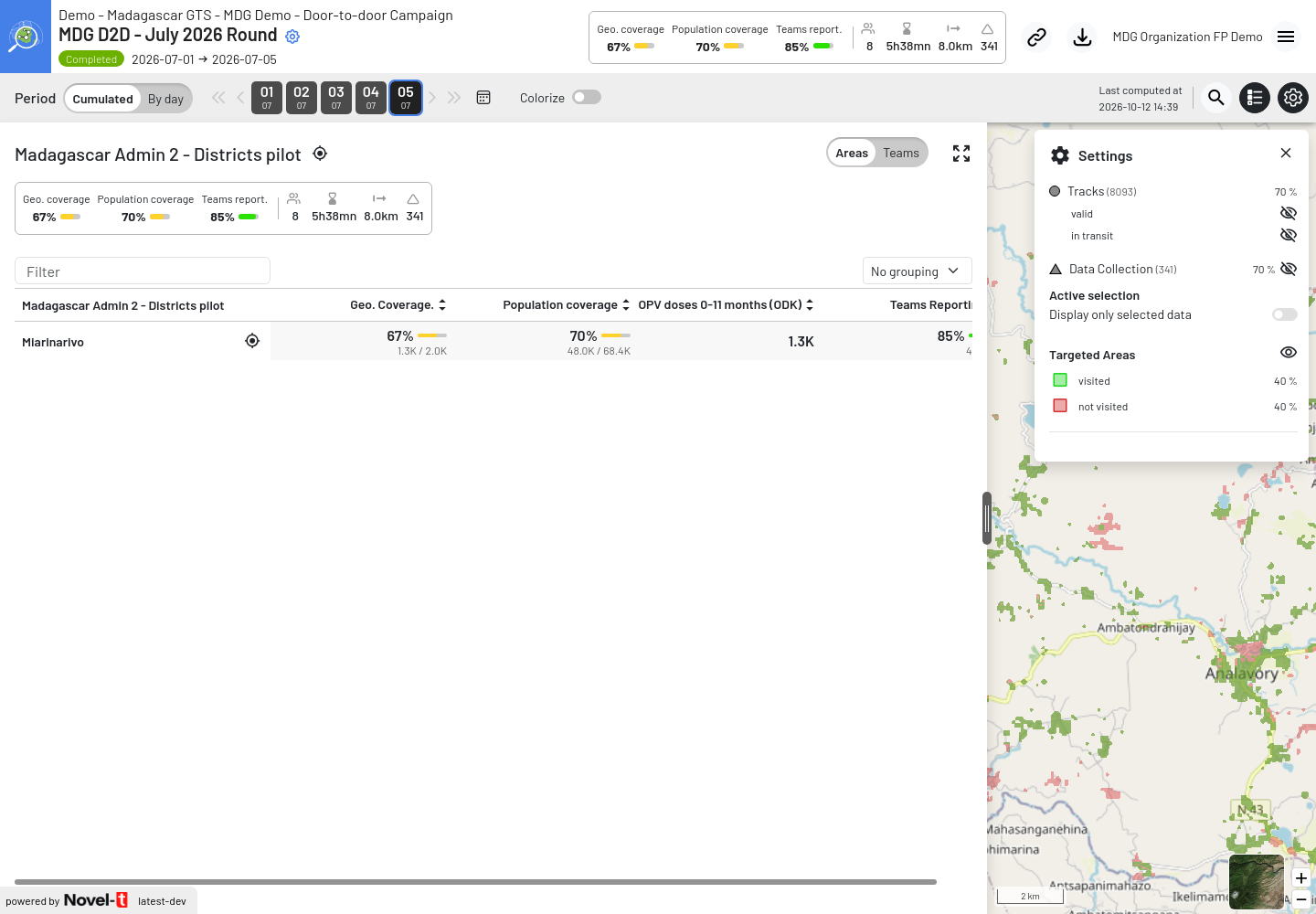
Map of the MDG D2D July 2026 Round at the end of the round: Geo. coverage 67 % (1.3K of 2.0K Targeted Areas visited), Population coverage 70 % and Teams report. 85 % (40 team-days reported of the 47 planned) in the header and the data panel, Targeted Areas not visited in red
Use the map to answer three questions every day:
- How far are we?
The header shows the global indicators: Geo. coverage (percentage of Targeted Areas visited), custom indicators such as the share of the target population reached, and Teams report. (teams reporting compared with teams expected).
- Where are the gaps?
In the left panel, the Areas tab lists the areas of the first base layer with their indicators. Click an area to drill down to the next level, down to the Targeted Areas (see Geo-Coverage Investigation). Visited Targeted Areas are shown in green, the others in red. Sort the list to bring the least covered areas to the top.
- Are the teams where they should be?
The Teams tab shows the activity of each team. Turn on the tracks in the Settings panel to see the paths of the teams and check whether red settlements were approached but not entered, or not approached at all.
Use the Period selector: Cumulated shows the progress since the first day; By day shows what was done on one day only, which is useful in the daily review meeting.
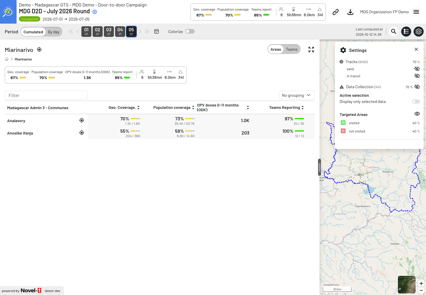
Drill-down to the Miarinarivo district: coverage and teams reporting of its communes, with the breadcrumb back to all areas
Note
Indicators are computed after the data is uploaded; the time of the last computation is shown as Last computed at in the map header. Data uploaded late are added at the next computation.
4. Plan the mop-up
Towards the end of the campaign (for example at the end of day 4 of a 5-day round):
Make sure all phones have uploaded their data (check Teams report.).
Download the Geocoverage Indicators in Excel, with Export Targeted Areas if you need the list of individual settlements (see Geocoverage indicators and Targeted Areas).
Filter the settlements or localities with a low Visited (%) to build the missed settlement list (see Get the missed settlement list).
Assign the missed settlements to mop-up teams and follow them on the map on the mop-up day.
5. Report and learn
After the campaign:
Download the tracks, ODK submissions and indicators you need for the final report (see Downloads and GPS tracks), or connect your reporting tool to the Open Data service.
Share the final missed settlement list with the planning team to improve the microplan of the next round.
Tracking Rounds are archived automatically about 30 days after their end date: the map then keeps only the final indicators. Tracks remain available through the track export.
See the post-campaign checklist in Door-to-door campaign checklists.