Downloads and GPS tracks
The map of a Tracking Round (TR) lets you download its data for offline analysis, reporting or archiving:
GPS tracks recorded by the field teams (this page);
ODK submissions collected with GTS Collect (see ODK form submissions);
Geocoverage indicators and Targeted Areas (see Geocoverage indicators and Targeted Areas);
Stationary Activity report, a custom report prepared on request for some Madagascar rounds (see the note in Stationary campaigns and fixed posts).
All of them are requested from the same Download options window and delivered in a single ZIP file. For recurring reports, consider the Open Data service instead.
Note
Any dashboard user who can open the map of a TR can download its data. Downloads contain personal data (user names, team codes, device identifiers, GPS positions): store and share them according to the data protection rules of your programme.
The Download options window
Open the download window
On the map of the TR, click the download icon in the header, next to the link icon. On a phone, open the menu and choose Export.
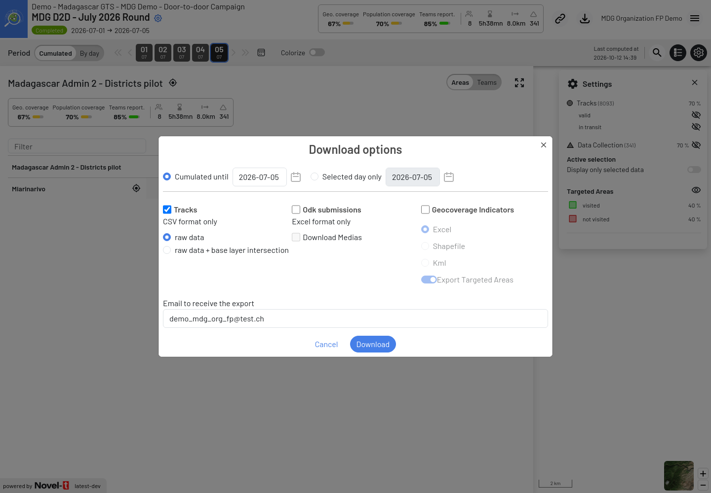
Download options window of the MDG D2D July 2026 Round, with tracks selected
Choose the period
At the top of the window, choose which days are exported. By default, the window uses the period currently selected on the map.
Cumulated until — all data from the first day of the TR until the selected date included.
Selected day only — only the data of the selected date.
Dates can be chosen between the start and the end of the TR (and not after today).
Choose the data
Tick one or more data types:
Tracks — CSV format only, see Track file content below.
Odk submissions — Excel format only, see ODK form submissions.
Geocoverage Indicators — Excel, Shapefile or Kml, see Geocoverage indicators and Targeted Areas. This section is only shown when the TR has Targeted Areas.
Stationary Activity — a custom report prepared on request for some Madagascar rounds (see the note in Stationary campaigns and fixed posts), shown with the date of its Last computation only when this report exists for the TR. The export contains this last computed report, whatever the period selected. The stationary activity detected by GTS is exported with the Geocoverage Indicators instead.
Enter the e-mail address
Email to receive the export is pre-filled with the e-mail address of your account. You can replace it with another address, for example the one of the analyst who will use the data.
The Download button is enabled once at least one data type is ticked and the e-mail address is valid.
Size and time estimate
When an export is expected to take more than 5 seconds, the window shows an estimate such as Your download will be ready in approximately 35s. (~6.43 MB). It is updated when you change the data types, formats or options, but not when you only change the period. Use it to decide whether you really need all the options: a smaller selection (one day instead of the whole round, no media, no base layer intersection) is ready much faster.
The estimate is only indicative. It does not count tracks already moved to archive storage, so it can be too low for old Tracking Rounds. Large exports are never refused.
When indicators are being recomputed
While GTS recomputes the indicators of the TR, the window shows Indicators recomputation is running, please wait for it to finish before downloading. and the Download button stays disabled, whatever the data types ticked. The window checks again every 10 seconds and enables the button as soon as the computation is finished. This avoids exporting half-updated indicators.
Receive the file
After you click Download:
The window shows The export has started with the progress of the export (for example Export tracks: Generating csv files…). If other exports of the same TR are running, it shows The export has been queued and the number of exports to wait for.
When the file is ready, it is downloaded automatically by your browser and the window shows Your export is ready ! with a direct link, in case the browser blocks the download.
In any case, an e-mail GTS: Your download is ready is sent to the address entered, with a download link.
You do not need to keep the window open: closing it does not cancel the export, and the e-mail is still sent. If somebody already requested exactly the same export for the same TR and it is still queued or running, GTS does not start it twice: you are added to the recipients of the e-mail.
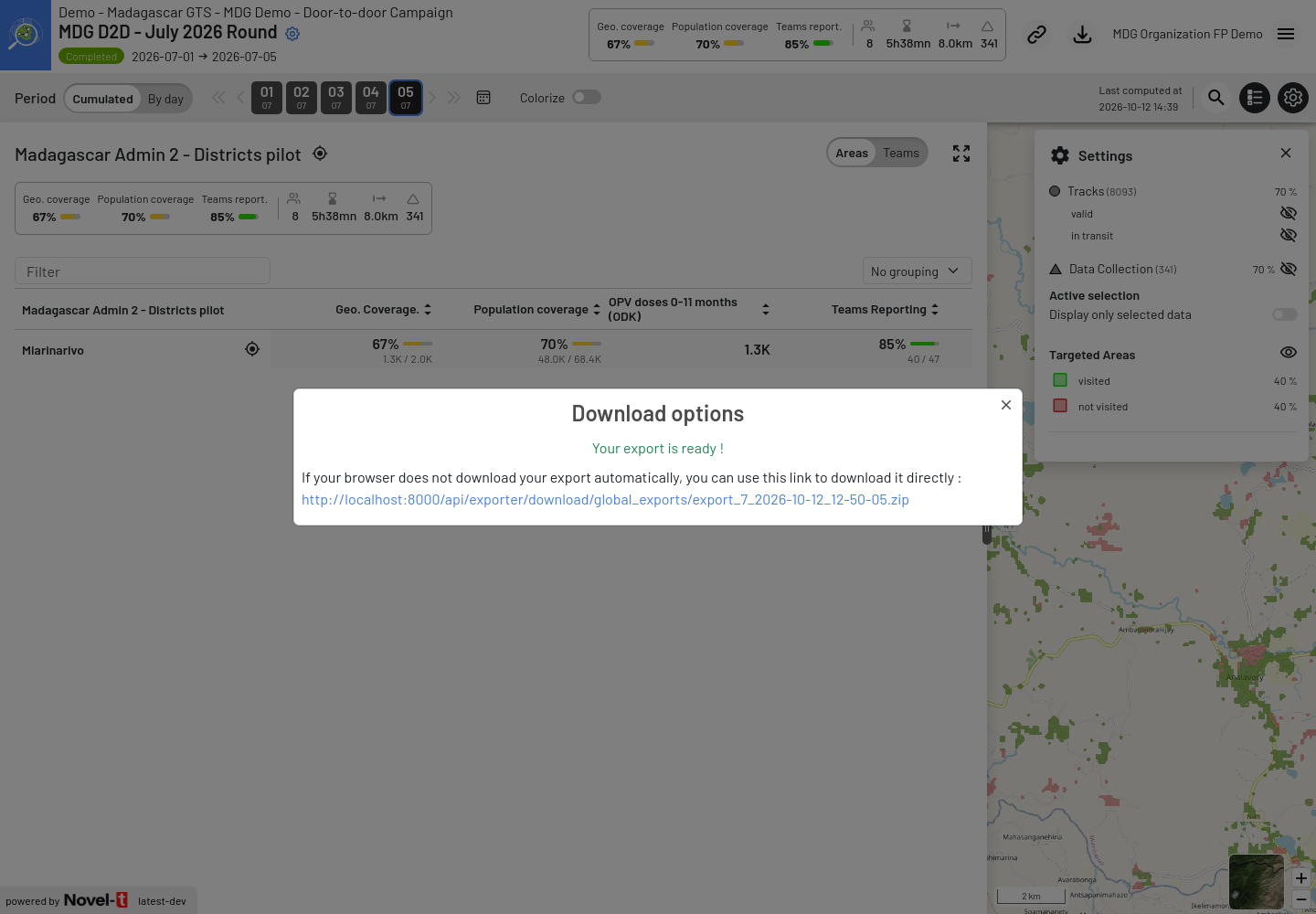
The Download options window once the export is ready, with the direct link to the file
Important
The download link is valid for 4 days. After that, the file is deleted and the link shows It seems that your file doesn’t exist anymore…. Request a new export if needed.
Anyone who has the link can download the file while it is valid: do not forward the e-mail outside the people authorized to see the data.
If the export fails, the window shows The export has failed with the reason, and an e-mail Error during export of your data is sent. GTS retries the export once automatically, at the next full hour: if the retry succeeds, you still receive the GTS: Your download is ready e-mail. If the problem persists, contact the GTS support with the date and time of your request.
Content of the ZIP file
The ZIP file is named export_<TR ID>_<YYYY-MM-DD>_<HH-MM-SS>.zip. It contains one folder per selected data type
(Tracks, ODK_submissions, Geocoverage_indicators, Stationary_activity) and an info.txt file
that records the IDs of the TR and of the Field Activity, the export time and the period (Cumulated until or
Selected day only and the date).
Archived Tracking Rounds
GTS archives Tracking Rounds automatically about 30 days after their end date: only the final indicators are kept on the map. Separately, GPS tracks older than about 30 days that no active round needs are moved to an archive storage.
When you open the download window of an archived TR, it shows This tracking round has been Archived. Only final indicators have been preserved. Ask GTS team to recover full data if needed. and:
the period cannot be changed: the export uses the period currently selected on the map;
Export Targeted Areas is disabled, because indicators by Targeted Area are no longer kept (this is the data the message refers to);
Tracks and Odk submissions can still be downloaded. Since Release 3.8, track exports include the tracks moved to the archive storage, so you do not need to ask the GTS team for them. These exports take longer than for an active round.
Download tracks
Open the download window and choose the period.
Tick Tracks.
Choose the content:
raw data (default) — one row per GPS point. This is the fastest option.
raw data + base layer intersection — the same rows, plus the administrative areas and the Targeted Area in which each point was recorded. Use it when you need to analyse tracks by district, commune or locality without a GIS tool. This option is only useful when the TR has Targeted Areas, and it takes much longer to produce.
Check the e-mail address and click Download.
The export contains all the tracks of the Field Activity recorded on the days of the period, including
tracks recorded outside the Targeted Areas and tracks of the other Tracking Rounds of the Field Activity on these
days. Tracks are exported in CSV format only. To display tracks in a GIS tool such as QGIS, import the CSV as a
delimited text layer using the Lon and Lat columns (WGS 84 coordinates).
Track file content
The Tracks folder contains Tracks_0.csv, then Tracks_1.csv, etc. Each file holds at most 1,000,000
rows, so that it can still be opened in Excel.
Column |
Description |
|---|---|
Organization |
Name of the Organization. |
Field Activity |
Name of the Field Activity. |
Tracking Round |
Name of the Tracking Round. |
<Base layer> ID / <Base layer> Label |
Only with raw data + base layer intersection: identifier and label of the area of each base layer (for example Madagascar Admin 2 - Districts pilot) containing the point, from the largest to the smallest layer. |
Targeted Area ID / Targeted Area Label |
Only with raw data + base layer intersection: Targeted Area containing the point. |
Username |
User name of the field staff account used on the device. |
Team Code |
Team code entered in GTS Tracker. |
IMEI |
Identifier of the Android device. |
Valid |
1 if the point respects the speed limits of the Tracking Round and was not flagged as suspicious (for example an impossible jump), so it can be used for coverage; 0 otherwise (for example a point recorded in a vehicle). |
GPS Status |
1 if the device recorded a new position, 0 if the position is the same as the previous point (the device did not move or had no new GPS fix). |
GPS Timestamp (UTC) |
Date and time given by the GPS signal, in UTC (format MM/DD/YYYY HH:MM:SS). |
Phone Timestamp (UTC) |
Date and time of the device clock, converted to UTC (same format). It can differ from the GPS time when the device clock is wrong. |
Lat / Lon |
Latitude and longitude of the point (WGS 84). |
Accuracy m |
Accuracy of the position reported by the device, in metres. |
Speed mps |
Speed reported by the device, in metres per second. |
Track ID |
Unique identifier of the point in GTS. |
Note
Times in the export are in UTC, like the times marked (UTC) in the map pop-ups. In Madagascar (UTC+3), a point recorded at 09:00 local time appears as 06:00 in the export. The days of the period are also UTC days, as on the map (see Days follow UTC): a point recorded at 01:00 local time on 2 July is exported with 1 July.