Data Downloads
The GTS dashboard provides for downloading of Tracks, ODK form data and Targeted Areas data in a variety of formats.
Tracks
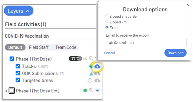
Click on the download control  to open the download option popup form, from within the form select the data format desired
MS Excel Workbook, ESRI Shapefile format, or Keyhole Markup Language (kml) used with Google Earth.
to open the download option popup form, from within the form select the data format desired
MS Excel Workbook, ESRI Shapefile format, or Keyhole Markup Language (kml) used with Google Earth.
Depending on the size of the file, generation may take a few minutes; an email address is therefore requested to which a notification and download link will be forwarded.
Download Options for Tracks data
MS Excel Workbook
Select “Excel” to download an Excel Workbook of tracking data, each line represents an individual tracking point.
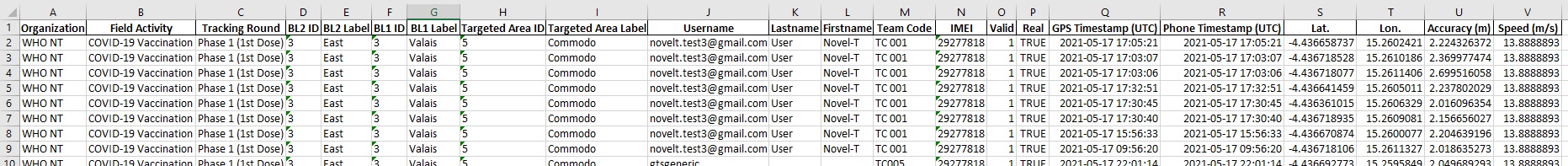
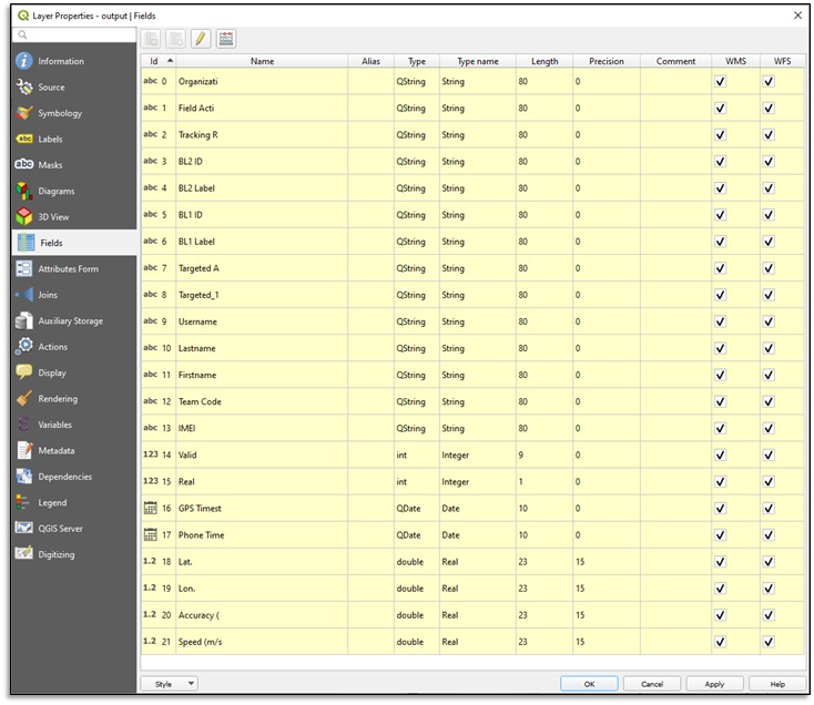
Excel Download of tracking data
Data field name |
description |
|---|---|
Organization |
Organization Name |
Field Activity |
Field Activity Name |
Tracking Round |
Tracking Round Name |
BL2 ID |
Base Layer ID (Depending on the number of base layers additional columns may be added for BL# ID) |
BL2 Label |
Base Layer Label (Depending on the number of base layers additional columns may be added for BL# Label) |
BL1 ID |
Base Layer ID |
BL1 Label |
Base Layer Label |
Targeted Area ID |
Targeted Area ID |
Targeted Area Label |
Targeted Area Label |
Username |
Field Staff Username |
Lastname |
Field Staff Last Name |
Firstname |
Field Staff First Name |
Team Code |
Team code entered in the mobile application when tracking |
IMEI |
Unique ID (International Mobile Equipment Identity) of the Android device used for tracking |
Valid |
Identifies if the track respects field activity accountability rules regarding speed- if accountability is respected (1) otherwise (0). |
GPS Status |
Identifies if the track is truly derived from a GPS signal (1) or estimated based on previous tracks when no GPS signal was acquired (0) |
GPS Timestamp (UTC) |
Date and time when the track was collected (based on Android device settings) |
Phone Timestamp (UTC) |
Date and time when the track was collected (based on GPS readings) |
Lat. |
Latitude of the tracking point |
Lon. |
Longitude of the tracking point |
Accuracy (m) |
Geopositioning accuracy (based on GPS readings) recorded when the track was collected by the GTS Mobile Application |
Speed (m/s) |
Actual speed (based on GPS readings) recorded when the track was collected by the GTS Mobile Application |
Shapefile
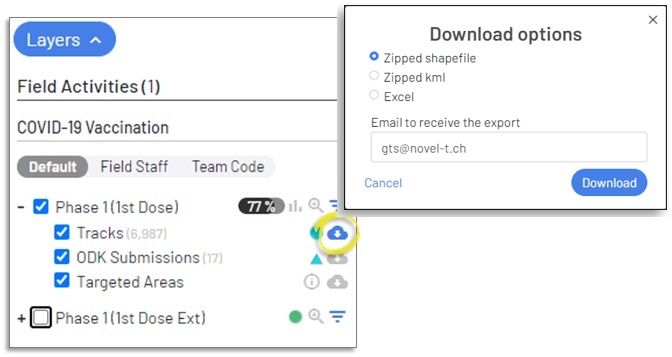
Select “Zipped shapefile” to download a .zip archive of the ESRI shapefile components of the tracking data that may be opened in a GIS application such as ArcMap or QGIS.
Download Options for Tracks data
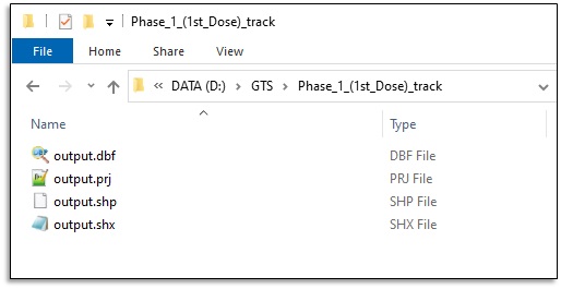
Shapefile components delivered by the GTS
The Shapefile download contains the same data fields as those included in the csv download.
Shapefile fields included with the GTS download
KML
Select “kml” to download a Keyhole Markup Language file of tracking data.
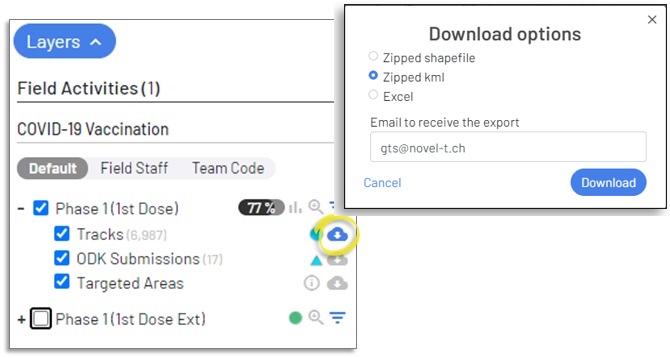
KML Download of tracking data
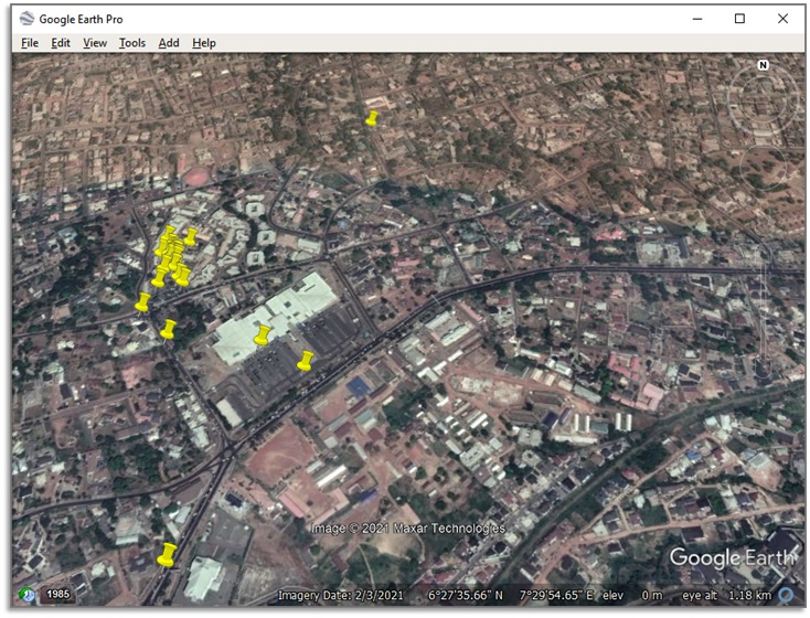
Tracks depicted on Google Earth
ODK Forms
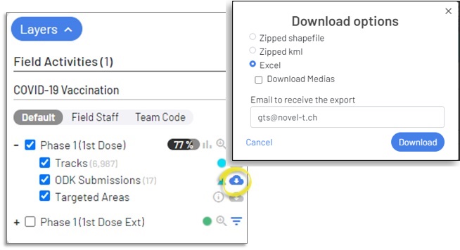
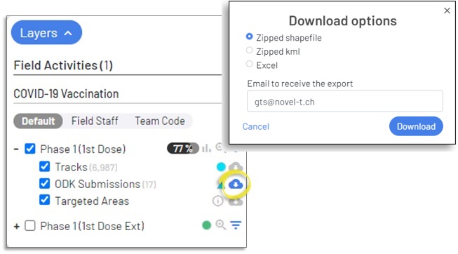
Click on the download control to the right of the ODK submissions overview to open the download options popup form, from within the form select the data format desired
MS Excel Workbook, ESRI Shapefile format, or Keyhole Markup Language (kml) used with Google Earth.
MS Excel Workbook
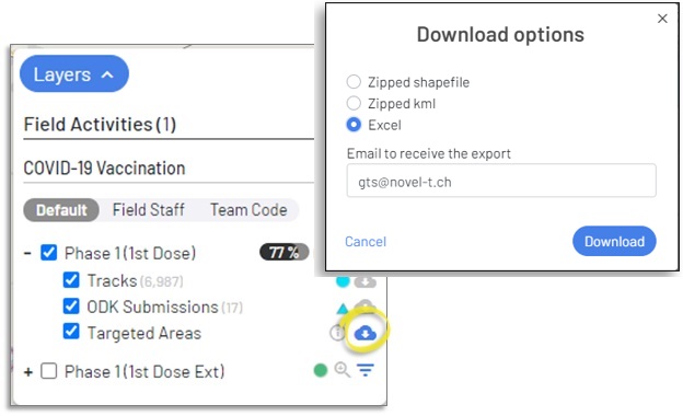
Select “Excel” to download an Excel Workbook of ODK data, each line represents an individual tracking point.
Excel Download of ODK data
Data field name |
description |
|---|---|
org_name |
Name of the Organisation containing the field activity (assigned by GTS). |
field_activity_id |
ID of the field activity used when tracking (assigned by GTS). |
field_activity_name |
Code of the field activity (assigned by Organisation Focal Point). |
submission_id |
ID of the ODK data upload (assigned by GTS). |
tr_round_name |
Name of the Tracking Round (assigned by Organisation/Field Activity Focal Point). |
tr_round_id |
ID of the Tracking Round (assigned by GTS). |
tr_round_start |
Start date of the Tracking Round (assigned by Organisation/Field Activity Focal Point). |
tr_round_end |
End Date of the Tracking Round (assigned by Organisation/Field Activity Focal Point). |
last_track_gps_timestamp_utc |
Date and time in UTC when the ODK form was completed collected by the GTS Mobile Application from the GPS signal |
submitted_at_localized |
Date and time in local time when the ODK form was completed calculated by the GTS Mobile Application based on UTC time |
imei |
International Mobile Equipment Identity number of the Android device collecting tracks |
user_firstname |
First name of the user logged in to the GTS Mobile Application while tracking |
user_lastname |
Last name of the user logged in to the GTS Mobile Application while tracking |
user_username |
User name of the user logged in to the GTS Mobile Application while tracking |
team_code |
Team code entered into the GTS Mobile Application by the user when collecting tracks |
teamcode_norm |
Normalised Team code (spaces removed and all upper case) |
form_id |
ID of the ODK form (assigned by GTS). |
form_name |
Name of the ODK form (assigned by Organisation/Field Activity Focal Point). |
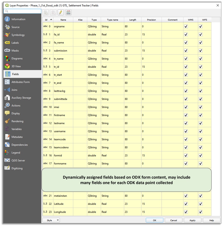
ODK Contextual data (may include many lines) |
Dynamically assigned attributes for each data item collected by the ODK form |
meta_instanceID |
ODK assigned unique ID for form instance |
Latitude |
Latitude of the geopoint collected by the ODK from |
Longitude |
Longitude of the geopoint collected by the ODK from |
Shapefile
Select “Zipped shapefile” to download a .zip archive of the ESRI shapefile components of the ODK form data that may be opened in a GIS application such as ArcMap or QGIS.
Download Options for ODK data
The Shapefile download contains the same data fields as those included in the csv download.
Shapefile fields included with the GTS download
KML
Select “kml” to download a Keyhole Markup Language file of ODK data.
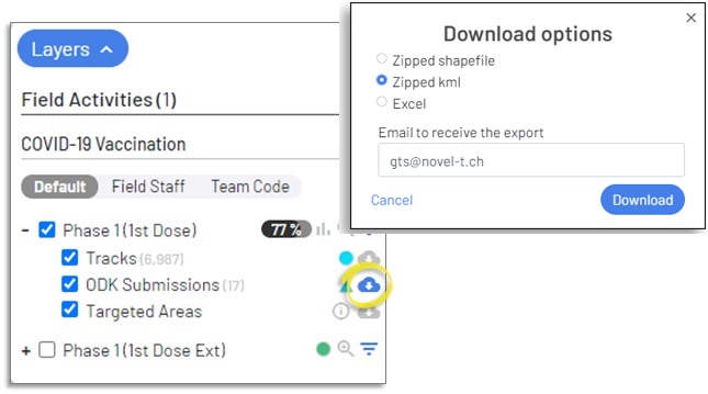
KML Download of ODK data
ODK form collection locations depicted on Google Earth
Targeted Areas
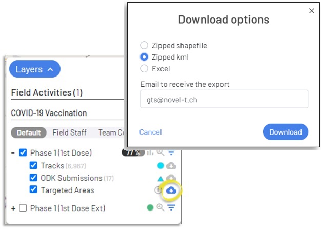
Click on the download control to the right of the Targeted Areas overview to open the download options popup form, from within the form select the data format desired
MS Excel, ESRI Shapefile format, or Keyhole Markup Language (kml) used with Google Earth.
Excel
When downloading targeted areas in MS Excel workbook format, each base layer assigned to the targeted areas and the targeted areas appear on separate worksheets within the Excel workbook.
Download Options for Targeted Areas
Caution
The option to allow Targeted Areas download is configured when uploading targeted areas to the Tracking Round in the Administrative Console.
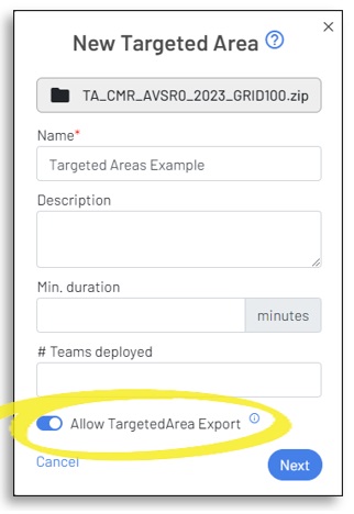
You may opt to not allow the download of Targeted Areas because may potentially require much bandwidth and could take considerable time.
The number of fields that appear in the Targeted Areas worksheet, if “Export Targeted Areas” is selected, depends on the number of base layers attributed to the Targeted Areas for aggregation, as well as the number of sum indicators assigned if any.
The table below depicts the fields that would appear in the targeted areas worksheet if three base layers and one sum indicator are attributed to the targeted areas layer.
Data field name |
description |
|---|---|
Organization |
Name of the Organisation containing the field activity (assigned by GTS). |
Field Activity |
Name of the field activity (assigned by Organisation Focal Point). |
Tracking Round |
Name of the Tracking Round (assigned by Organisation/Field Activity Focal Point). |
BL3 ID |
ID of the Base Layer (assigned by GTS). |
BL3 Label |
Label of the Base Layer (assigned by Organisation/Field Activity Focal Point). |
BL2 ID |
ID of the Base Layer (assigned by GTS). |
BL2 Label |
Label of the Base Layer (assigned by Organisation/Field Activity Focal Point). |
BL1 ID |
ID of the Base Layer bottom-most base layer- contained by other base layers (assigned by GTS). |
BL1 Label |
Label of the Base Layer (assigned by Organisation/Field Activity Focal Point). |
Targeted Area ID |
ID of the Targeted Areas set by the GTS system |
Targeted Area Label |
Label of the Targeted Areas (assigned by Organisation/Field Activity Focal Point). |
Visited |
True/False whether the targeted area is considered visited based upon accountability rules |
Sum indicator |
Sum indicator of the targeted area such as population there may be more than one sum indicator |
X |
Longitude of the centroid of the Targeted Area polygon |
Y |
Latitude of the centroid of the Targeted Area polygon |
The table below depicts the fields that would appear in the base layers worksheet for the highest level of aggregation if three base layers and one sum indicator for population are attributed to the targeted areas layer.
Data field name |
description |
|---|---|
BL3 ID |
ID of the Base Layer (assigned by GTS). |
BL3 Label |
Label of the Base Layer (assigned by Organisation/Field Activity Focal Point). |
# Visited |
Number of targeted areas visited in the base layer |
# Targeted Areas |
Number of targeted areas in the base layer |
Percentage |
Percentage of targeted areas in the base that were visited |
X |
Longitude of the centroid of the Targeted Area polygon |
Y |
Latitude of the centroid of the Targeted Area polygon |
Population visited |
Estimated population visited in the base layer |
Population total |
Estimated population of the base layer |
Population percentage |
Percentage of estimated population in the base that was visited |
Subsequent base layer worksheets will add fields for their own base layer ID and Label and will adjust other data to represent detail at that level. The table below depicts the fields that would appear in the base layers worksheet for the second-highest level of aggregation if three base layers and one sum indicator for the population are attributed to the targeted areas layer.
Data field name |
description |
|---|---|
BL3 ID |
ID of the Base Layer (assigned by GTS). |
BL3 Label |
Label of the Base Layer (assigned by Organisation/Field Activity Focal Point). |
BL2 ID |
ID of the Base Layer (assigned by GTS). |
BL2 Label |
Label of the Base Layer (assigned by Organisation/Field Activity Focal Point). |
# Visited |
Number of targeted areas visited in the base layer |
# Targeted Areas |
Number of targeted areas in the base layer |
Percentage |
Percentage of targeted areas in the base that were visited |
X |
Longitude of the centroid of the Targeted Area polygon |
Y |
Latitude of the centroid of the Targeted Area polygon |
Population visited |
Estimated population visited in the base layer |
Population total |
Estimated population of the base layer |
Population percentage |
Percentage of estimated population in the base that was visited |
The number of fields and records will increase with each subsequent aggregated base layer, ending with the targeted areas layer as the lowest aggregation level.
Shapefile
Select “Zipped shapefile” to download a .zip archive of the ESRI shapefile components of the Targeted Areas that may be opened in a GIS application such as ArcMap or QGIS.
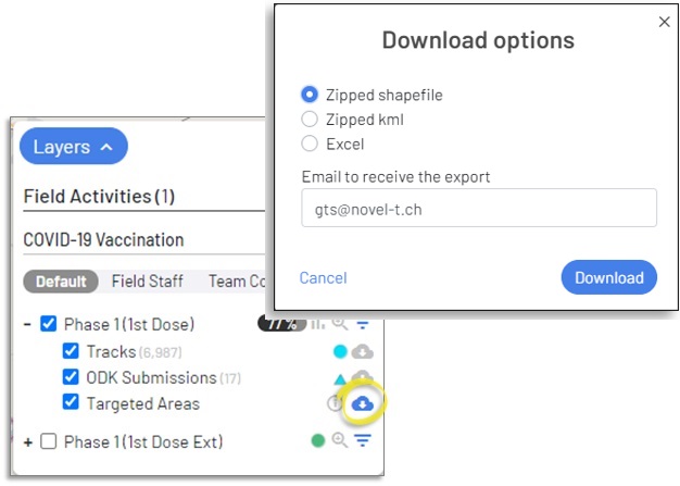
Download Options for Targeted Areas
The Shapefile download contains the same data fields as those included in the Targeted Areas worksheet of the Excel download.
KML
Select “kml” to download a Keyhole Markup Language file of the Targeted Areas that may be opened in a GIS application such as Google Earth.
Download Options for Targeted Areas
The Shapefile download contains the same data fields as those included in the Targeted Areas worksheet of the Excel download.