Inputs
The GTS dashboard accepts uploads of ODK Collect forms as .xml files as well as Base Layers and Targeted Areas as ESRI shapefiles.
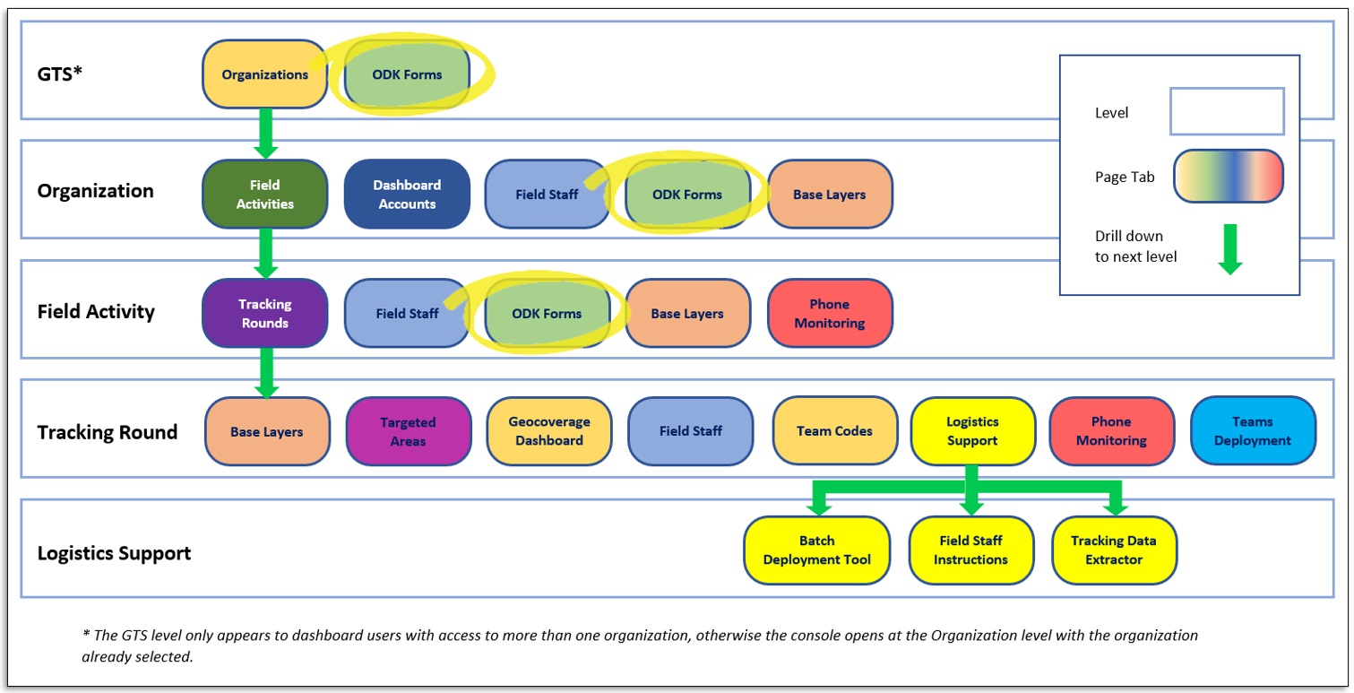
ODK forms
ODK forms may be attributed at three levels:
Across all Field Activities in the GTS (only GTS system admins may upload ODK forms at this level)
Across all Field Activities in an Organization
For a particular Field Activity only
ODK forms may be uploaded either as basic .xml files or as .zip archives that contain the .xml files with any associated itemsets.csv files for large lists and media directories for media files.
These files may be created using the ODK Collect XLSForm or ODK Build utilities in the same manner as they would for use with standard ODK Collect. For more details see the ODK Collect information Online
Base Layers
Base layers are uploaded to the GTS dashboard as .zip archives of ESRI Shapefile components. Base layers typically consist of administration levels which may be sourced from the GeoPoDe website, however any nested geospatial polygons may be used such as watersheds or non-administrative boundaries. The GTS does not limit the number of base layers that may be uploaded, although it is best to have the base layers nested within higher levels, the sequence of the hierarchy is defined when assigning the base layers to a targeted areas layer.
Base layers should include the attributes of a unique ID and a feature label that will be used in the map display and downloads.
Targeted Areas
Similar to Base Layers Targeted areas are uploaded to the GTS dashboard as .zip archives of ESRI Shapefile components. Targeted areas are typically settlements, gridded populated areas or buffers around points of interest such as health facilities. Targeted areas constitute the lowest level of aggregation.
Targeted areas should include the attributes of a unique ID and a feature label they may also include other attributes that may be exploited by the GTS:
Sum Indicators: Numeric values, such as population, that will be summed across aggregation levels (more than one field may be selected)
Average Indicators: Numeric values that will be averaged across aggregation levels (more than one field may be selected)
Group Indicators: Text values used to divide features into groups, such as settlement types - BUA, HA or SSA (more than one field may be selected)
Visit date start: Date value after which tracks will be considered valid.
Visit date end: Date value before which tracks will be considered valid.
Min duration: Minimum time spent in a targeted to consider the area as visited (to specify different duration for different features, such as a function of area or population).
Note
The uploaded .zip archive must include a CRS (Coordinate Reference System) projection file (.prj) for the GTS to accept the file.
Shapefile components that should be included in the .zip archive are:
Geometry (. shp) - Required minimum for a Shapefile
Index (.shx) - Required minimum for a Shapefile
Database table (.dbf) - Required minimum for a Shapefile
Projection (.prj) - Required By the GTS